You might be wondering why I've not posted anything new from the trip to the O RO Ranch in the past couple of days. There are several reasons.
Over the weekend, I bought 4 new doors to replace the same number upstairs in my house. The house came with ugly, unpainted luan doors - just flat, plain, boring doors. The front door, however, is in a colonial-paneled style - much nicer. I replaced the closet door in the living room to match (it's right by the front door - the dissimilarity was jarring) a while back and have planned ever since to do the rest of the doors upstairs. Tracy and I worked on those over the weekend: I cut holes for the door handles while she counter-sunk the hinges for me - with a chisel, since I don't have a router. All well and good; time consuming, but not difficult.
But the frames aren't true anymore: the house has settled since it was built. I planned on that, and bought a sander so I could sand down the doors and make them fit. What I didn't plan on was how much reshaping I'd have to do: the closet door mostly fit - I was able to do that bit of sanding by hand. But some of these doors (or frames, really) need more than a millimeter of adjustment. With the little 1/4 sheet sander I got and 60-grit sandpaper, that doesn't seem to be possible: I've sanded for over an hour on one of the better fitting doors (the door to my room) and it still doesn't fit. I just don't have the right tool.
Fortunately, Tracy's dad is going to loan me a 21-inch belt sander. That ought to do the trick and will be easier to use (for me) than a table saw (which I neither have nor know how to use).
The other reason for the delay stems from my frustration in assembling nice panoramas to post and discuss. I did the Monkeytown panorama by hand, in Photoshop. It looks good, but it was time consuming. Spending that amount of time assembling 2 photos isn't too bad; some of my panoramas have 10 photos. Lining all of those up would take serious time.
Canon has software that'll automate the merger (PhotoStitch). It's easy to use and fast. But it's not terribly good at lining things up. Decent, but not great. And it doesn't let you tweak its merger after (or before) it does its thing. What's more, on my Hackintosh, it fails with an OS error whenever it tries to save anything. Frustrating.
Photoshop offers a more powerful automated merging solution. It lets you do more work tweaking the setup and even tries (and typically fails, in my experience) to figure out in what order and how the photos should line up. Even when it fails to line them up, you can hold its hand and show it how it ought to align the photos. It's harder to use, is very, very slow, but produces better results. Better, but still not great - I can achieve much better doing it by hand (sadly!).
The crux of the problem, though, is this: I want the output as a photo, sure; but what I really want is a QuickTime VR. That's how you really want to look at a panorama - especially those as wide as some of the ones I've taken. But Photoshop won't make them, QuickTime Pro won't let me make them, and the authoring software I demoed I can't make heads or tails of: when I tried to use it, the result was a panorama that was really bad looking, like I'd zoomed way out, or something. Canon's software will make them, but it won't let me import an already-pieced-together panorama for conversion to QuickTime VR (it complains that the aspect ratio is too great - you're limited to 10:1).
Okay, I thought, I'll just chop up the tiff I exported from Photoshop and have the Canon stuff use that. Nope. Even though the images were perfect for merging, PhotoStitch managed to botch it. Can't figure out why, but it did.
Again - I don't seem to have the right tool (or tools).
My current plan is this: manually merge the photos in Photoshop so that I can ensure they're correctly lined up and look as good as possible (I shot them all with a polarizer (a big mistake) so all of them have an annoying luminance gradient I have to deal with). Then, chop them into pieces. At the edge of each of the pieces, I'll attach a large grid or target or something of the sort that should make it dead obvious for the Canon software how the photos fit together. Then I'll use PhotoStitch to export a QuickTime VR. It'll be a pain, but I'm hoping for good results.
And, hopefully, in a couple of days you'll find some high-quality panoramas of the ranch on here to explore.
Wednesday, August 22, 2007
Monday, August 20, 2007
The Cliff Dives
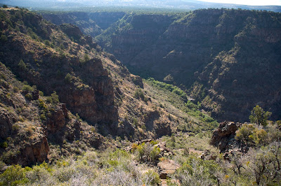
On our second day at the O RO Ranch, Tracy and I went with Jack and Daniel to the Cliff Dives - a particular spot in a canyon on the ranch's southern border. You can see the cliffs (and the falls) in the photo above - they're in the lower-right-hand middle of the photo: that flat, brown-and-white patch in the green of the gorge between the canyon walls; it's easier to view if you follow the link over to Picasa.
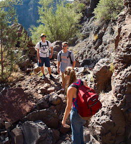 Our descent to the Dives followed the fold in the canyon visible in the photo at top, stretching from the lower-left-hand corner to roughly below the cliffs; from there, we turned to our left and scrambled up the photo frame to the cliffs. The photo at right shows us on the "trail" - really, it was a rarely-flowing, rapidly-falling stream down from the plateau to the canyon floor that ran over large volcanic boulders. The terrain was difficult, but manageable. The morning was cool - that helped a lot: in spite of the coolness, we were hot by the time we'd made it halfway down the stream bed.
 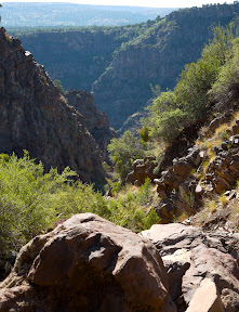 The vistas were gorgeous, both looking out across the canyon, as in this photo, as well as looking back up the way we had just come. Although one of the more beautiful spots on the ranch, it's remoteness and the difficulty of the hike make it rarely frequented. Jack guessed that (not counting Native Americans), we were among 10-20 people who had ever hiked down to that spot. Impossible to prove, but an impressive claim, nonetheless. And one did feel the isolation of the spot - much more strongly than I've experienced in the mountains around here.
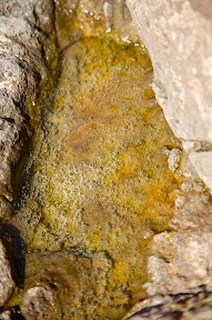 Halfway down the stream bed, we came to a large slab of lava rock that had collected pools of water, either from the recent rains or the receding water from the stream bed (still audible in some places, deep under the rocks). The disks in the water in this photo are bubbles - not eggs of some sort, but simple air bubbles. Some combination of heating from the sun and trapped air in the porous rock must have caused the bubbles to form. In the direct sunlight, the effect was quite stunning, particularly with the golden background provided by the algae that had formed in the bottom of the pool. We saw only a couple of these pools - it struck me as odd that there were so few. Perhaps the conditions for them to form are fairly specific?
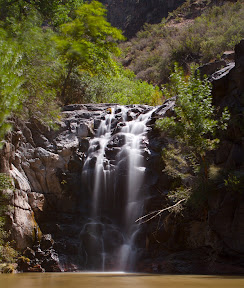 Down at the cliffs, it was almost like another world. With the constant availability of water, large deciduous trees (maples and the like) were in evidence - we never saw those up on the plains. The falls were gorgeous. The top of the cliff (just at the upper right of the frame) must be some 60 feet high - it was from there that Jack and Daniel jumped into the pool below (though they didn't dive from that height). We've pictures of them jumping - frozen in mid air and just as they hit the water; I'm going to try to composite a time history of a jump together and post that, so you can see the whole jump in one picture. Should be interesting.
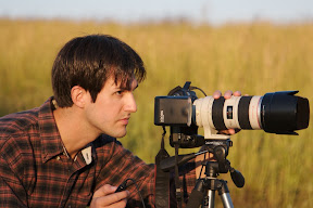
 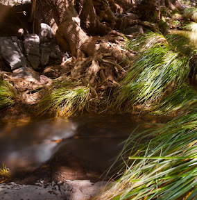 Due to the variability in water level at the base of the cliffs (it had quite recently flooded some three or four feet higher than the level at which we saw it), the roots of some of the trees were magnificently twisted and exposed. This picture shows one of my favorites, just across from the flow of water exiting the pool at the base of the cliffs. Just off-frame, to the left, is another fall, shown below, fed by the flow. These photos made lugging my tripod down (and up!) the canyon wall well worth it (though actually, the lenses and camera bodies I carried weighed more than the tripod). A friend loaned my his Canon backpack (and a really nice lens) which made carrying everything possible (and even fairly comfortable). I highly recommend a good, compartmentalized pack if you're going to lug your camera on hikes!
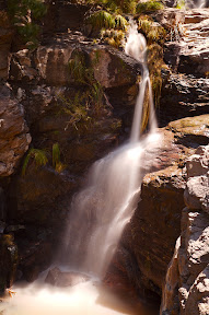 The cliffs for which the spot is named are really just one set in a series of cliffs and falls that range from that point down the canyon floor. We didn't explore in that direction, but I did walk back far enough to take a photo of this second set of falls. The tree roots in the previous photo are just off frame in the upper middle, and the falls from the first photo are in the background at the top-right of the frame. There was no jumping from this cliff, by the way: the pool at the base of the fall is quite small - too small a target to make in a jump, even if were it deep enough.
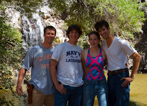 We stayed down at the falls for most of the day and hiked some up stream - all the way to a fork in the canyon wall. (Jack boldly declared we were the first humans to ever set foot in that part of the ranch - I tend to think some Native Americans or Cowboys from time past have been there - but who knows? It was remote country, and not easily reached.) Before leaving we stood in front of the tripod and I got a picture of the four of us. Not sure what I did wrong, but the trees behind us are in focus, where we are not. I might have forgotten to turn autofocus back on....
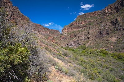
On the way out, I took this picture - a better look at the canyon, since the sun was at my back. It's unfortunate that scale can't be easily conveyed in a photo such as this - the canyon is vast and imposing when you're there, but just looks... bland in a photo.
Thursday, August 16, 2007
Ranch Flora

When most people hear "Arizona," they probably think of cacti and desert - a friend of mine calls it "kitty-litter land," in reference to a remark uttered by a Briton upon landing in the southwest: "It's wall-to-wall kitty litter!" While Phoenix certainly fits this description, the area around Prescott is much prettier with much more varied vegetation.
 That said, there are right many cacti. Of particular note is the century plant, which abounds on the ranch. If you've never seen one of these things up close, it's hard to imagine just how tough they are: they say that if you step on one, the central spike will drive through the bottom of your shoe. I can believe it - these things look like they ought to be soft, but are rock-hard. Indeed, they're something of a problem on the ranch. While the cattle and horses typically avoid the plants, either may step on one when a mounted cowboy is chasing a cow - and the results are disastrous. Not only are those spines sharp, but they also secrete an enzyme that enters the puncture and significantly retards healing. Not nice at all.
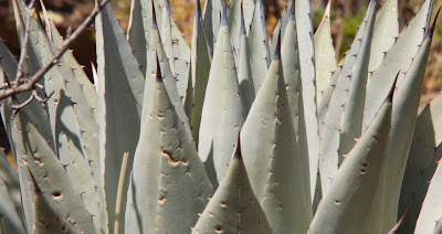
 And, unsurprisingly, they spread. After the plant reaches maturity, they send up colossal stalks topped with flowers that develop seed pods. These several-meter-tall, bamboo-like stalks enable the plant to scatter seeds over a fair distance - not too far, but far enough. The result, after time, is large patches of century plants, amongst which the cattle and horses can't graze, around which a periphery of smaller plants hide amongst rocks, as though lying in wait for the unsuspecting horse or cow. Or person. The ranch handymen try to get to the stalks early in development with machetes, lopping them off before they can go to seed - but there are so many of them over so much land, it's just not possible to get them all.
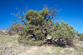 Another troublesome plant is the ubiquitous juniper. While not as dangerous as the century plant, the juniper causes problems by drawing an enormous amount of moisture out of the ground - moisture that, then, can't be used by the grass. As a result, around the base of nearly every older juniper is a bare patch of ground, where the grass has died out. In isolation, this effect isn't terribly problematic - but like all plants, the juniper spreads. After time, they can take over acres of field - and that's acres that can't be used for grazing. But they are pretty, in a wild sort of way. The action of the wind and dryness and, often, survived lightening strikes seems to carve them into fantastic shapes. And on a hike on a hot day, the shade under their branches is most welcome.
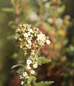 There are also right many wildflowers on the ranch. Perhaps not so many as you see in the East - but then, we were there in summer, and even in the East, there are many fewer wildflowers in summer as compared to spring. Yellows and oranges seemed the most common colors, but there were blues and purples as well, and whites. The terrain and elevation on the ranch is so varied, as is the ready availability of water, that a huge variety of plants are represented. These flowers came from the dryer, higher elevations, where we spent most of our time on the ranch.
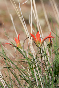 | 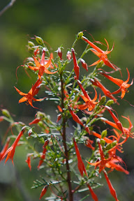 |
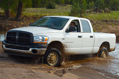
What Trucks are Meant For
 The trip to the O RO Ranch was awesome. More details will follow in posts throughout the rest of the week; many pictures will show up too - Tracy and I took 2290 (many duplicates). The process of weeding through all of those will take some time.
But for a first post, I thought I'd go with a rather humorous subject.
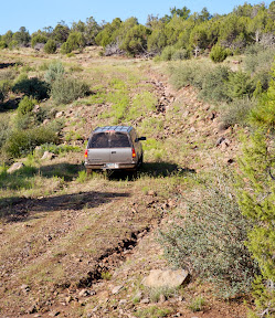 The ranch encompasses 235,000 acres of gorgeous, wild, rugged terrain. Roads on the ranch, by and large, are primitive and rough - unlike anything most people on the East Coast (at least) would ever think to associate with the term "road." Frequently washed out, rocky, muddy when it rains, and criss-crossed by streams of variable depth and width, even 4x4 trucks can't make it through, some of the time. After heading out to one of the vistas on the ranch, a recent visitor from the East Coast remarked "I didn't know cars could do that!"
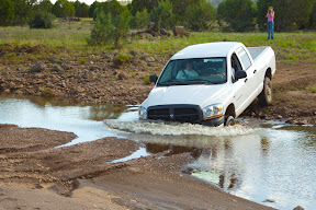 Surprisingly enough, that's what 4x4 trucks are meant to do: haul heavy cargo over rugged terrain. As opposed to, say, being prettily painted, cut down, and made to run on smooth-paved roads with performance tires.
P.S. I know the title's bad grammar. But hey.... We're talking about big, beefy trucks here. Grammar's got no place.
Wednesday, August 15, 2007
Foretaste
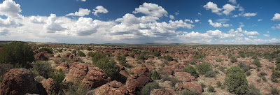
Still haven't had time to get together all the pictures I want to blog about from my trip to the O RO Ranch - but they're coming, never fear. In the meantime, here's a little taste of what's to come: Monkey Town Canyon, from a distance.
Subscribe to:
Posts (Atom)