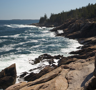
Wednesday, May 16, 2012

Acadia — Small Things Considered

The previous Acadia post focused on what we did and the large sights we saw. This one focuses on the smaller things we saw.

Seaweed


The amount of seaweed covering the rocks was unlike anything I've seen anywhere else. You can get a sense of it in the panorama from Sand Beach and in this photo Tracy shot of the waves crashing against the rocks.


I liked the true-green piece hanging off of the yellowish weed in this detail. And the bokeh.

Barnacles and Mussels


In addition to being covered with seaweed, many of the rocks below the high-tide line are encrusted with barnacles and host to beds of mussels. I've never really had the opportunity to look at barnacles so closely — they're more interesting than I thought.


I didn't realize that they built such long tubes around themselves. And the purplish dots all over the rock also appear to be barnacles — I assume they're really young ones. Notice how they're growing on the bigger ones and, in the first picture, on the mussels. They seem to pretty much be able to out-compete everything else on the rocks for space, once they take hold.


A final picture: lots of bokeh and a drop of seawater on the top of a lone mussel in a bed of barnacles.

Tidal Pools


The rocks on Acadia's shore trap a lot of water as the tide rolls out, forming tidal pools.


I've seen tidal pools at Litchfield (where we usually go to the ocean), but they're nothing like these. The Litchfield tidal pools rarely trap any animals and certainly don't have a "permanent" population of flora.


The tidal pools at Acadia, on the other hand, appear to have permanent populations of both flora and fauna. As you can see, there are several different types of seaweed that live on the rocks and in the pools, along with periwinkle, barnacles, mussels, tiny crabs and shrimp, and (though I didn't find any) starfish.


I really regretted that I didn't have a lense/filter/kit that would let me break the water. Something for additional illumination would have been nice, too, so I could have more depth of field. What we ended up doing was holding my raincoat over top of whoever was taking the picture so that the glare on the surface of the water from the sky was largely blocked. It helped, but wasn't perfect.

Gulls


There were a couple of seagulls that seemed quite interested in having their picture taken. We don't usually find gulls very interesting, but then again, we don't usually see gulls that are quite so photogenic.


This is a particularly nice moment in the gull's landing; unfortunately, the Rebel just missed focus for this one.


At this point, we figured the gull got irritated that Tracy wasn't taking its picture: every time she put down the camera, it started yelling at her. When she picked it back up, it would stop. She finally did get this shot.

Miscellaneous


Tracy shot these flowers, which were really pretty, for some reason. Probably because there was so little color, since Acadia is at least a month behind Virginia in terms of the arrival of spring.


I shot this mass of lichen. I regret not paying more attention to what's growing out of it.


Tracy shot this plant that is trying to grow in a cleft of rock. I really like the composition.


Something about this shot that Tracy took really caught my fancy. Seems like a good parting photo for this set from Acadia.

Acadia

Acadia is beautiful. It's a bit like northern Arizona (I'm thinking of the O RO Ranch, primarily) with a bit more green and mashed with the ocean. Tracy describes it as Arizona crossed with Alaska. The whole "Mount Desert Island" name is terribly misleading — it's about as far from a desert island as I can imagine.


I'm a terrible landscape photographer. I'm pretty convinced it's not the failing of my equipment (one can take good photos with a lousy camera and lousy photos with a good camera). It must be a failing of my eyes — I don't seem to be able to figure out how to compose, in such a small frame, the grandeur of a landscape. That's why most of my photos are of small-ish things: it's much easier for me to envision the final image when there is a clear, compact subject.

To "get around" this, we took mostly panoramas at Acadia. The hope is that in having a panorama, something of the overall grandeur will be preserved. The panoramas (like the image above) don't have a border and have a little bluish arrow in the upper right-hand corner. They are interactive — click and drag to pan around. If you click the arrow, it will full-screen the panorama.

Day One


We camped for the two nights we stayed on Mount Desert Island. Our campsite was small, but reasonably clean. We had neighbors on three sides, but they were very quiet. Actually, all of the occupied sites around us were very quiet.


A short walk from our campsite was the shore — we took this picture on the first day, which was the only day with a completely clear sky.

Day Two

The following morning was cloudy, which was a surprise and a disappointment. The forecast had changed since we had last looked at it: we expected several days of sun in Acadia before it started raining again, but discovered that we weren't going to get much sun and that it would rain the following day.


We took Park Loop Road and drove to Sand Beach — so named because it is actually a sand beach rather than a pebble or rock or cliff "beach."


It still doesn't look much like any other sand beach I've ever seen: there were piles of rock that were absolutely covered in seaweed piled on one side of the beach.


From Sand Beach, we took Ocean Path, which follows the Park Loop Road and the shore. We took frequent detours to walk out on the rocks and see the shore. The shot above is looking back towards Sand Beach. Notice the cave at the left of the frame and the gulls perched on the rock.


We also came across this cascade of fresh water from the recent rains running down to the ocean. It's in panorama here.


While we were playing on the rocks, a tour boat came into the cove near Sand Beach. Tracy got several good pictures of it; this was my favorite because it shows the far point of the cove.


We accidentally found Monument Rock, took this picture, and discovered later that it's a big enough deal that it has a name.


Ocean Path intersects Gorham Mountain Trail after Thunder Hole (which we visited but didn't photograph because it needs to be experienced and not really seen). Gorham Mountain is 525' tall and right next to the shore, so it affords spectacular views of the shoreline, including views back to Sand Beach.


From the summit, we followed the trail down the other side of the mountain back to Sand Beach. We got back on the Park Loop Road and then drove up to the summit of Cadillac Mountain.


At 1530', Cadillac Mountain is the highest point on Mount Desert Island. As you can see from the panorama, it was actually too high to really see anything well with the weather we had: everything below us seemed obscured by haze. I'm sure that in different weather, the view would be spectacular.


After Cadillac Mountain, we drove over to Wonderland. We're not really sure why it was named thus; after the shore line near Sand Beach, it seemed rather anticlimactic.


A bit further on from Wonderland is a still-operational lighthouse that the Coast Guard allows tourists to approach and view.


You can get quite close to the light itself; I also took a partial panorama, here.

Day Three

The second morning was also cloudy, and since rain was forecast, we struck camp and prepared to leave a day earlier than originally planned.


We drove over to Jordan Pond and checked out the gift shop. There is an old gatehouse that appears to be empty.


From there, we hiked around the pond on the Nature Trail.


At nearly the far end of the pond is the trailhead for Bubble Mountain. We decided, on the spur of the moment, to climb it. It has an elevation gain of 750'. You can see how steep it was — we had to climb up that rock wall with the blue paint on it.


We didn't stay long on top of Bubble Mountain because we saw the rain coming (both on the satellite picture — there was signal up there — and looking around). The idea of climbing back down those rocks when they were slick was not appealing to me. It wasn't too bad, even though it did start to rain, since we went down the back side and thus avoided the sheer walls of rock.


Heading down the back side of Bubble Mountain takes you through Bubble Divide, where the pines give way to a large stand of birch.


From there, you rejoin the Nature Trail and cross a cool wooden bridge. After we got back to the car, we left Acadia and started for home.

Friday, May 11, 2012

Flume Gorge

Today was split between hiking in New Hampshire and a lot of back-roads driving in Maine. We hit Flume Gorge in Franconia State Park near Lincoln New Hampshire around noon. It was cloudy when we started, but ended sunny. The great part was that the clouds were at the beginning, when I was most interested in getting pictures of the water — meant I could get reasonably slow shutter speeds without resorting to the neutral-density filter (which is a pain because it's too dark for the camera to either focus or meter).


This covered bridge was at the beginning of the trail; it was the first of two.


Shortly after the bridge we left the water, wandered through a cabin, and then came back to the water at this point. They call this "Table Rock," which seems a bit silly to me, as the feature isn't that unique, really.


From there, we followed the stream to the entrance to the gorge. There was a lot of water moving very fast.


The gorge itself was impressively narrow and deep. They'd set walkways above the water, hanging to the edge of the cliffs, so that we could be right in the gorge from beginning to end. The picture on the left shows the whole gorge, the picture on the right is a detail of the falls at the end, shot with a longer lens from essentially the same viewpoint.


This picture gives a good sense of how the walkways hung out over the water. Tracy is looking back the way we came, at the top of the cascade in the pictures above.


These falls, which were above the gorge, were created in an avalanche that occurred during a storm in the late 1800s. They call them "Avalanche Falls," appropriately enough.


These two pictures show the difference between shooting water at a high v. low shutter speed. Obviously, I prefer the low shutter speed (at right). It's actually not as smooth as I'd like. The sun was out at this point, so I couldn't get as long an exposure as I wanted (without resorting to the neutral-density filter).


After we left the gorge, the trail wound around back to where we started. Along the way, we passed another gorgeous cascade.


We came to another gorge, much wider than the first, spanned by another covered bridge.


This bridge has as its primary support the trunk of a single, massive pine tree. The tree was over 175 feet tall when it fell in the late 1800s and was used shortly after to build this bridge.

Thursday, May 10, 2012

Vermont

We started today in Winooski (part of Burlington), Vermont (just across from New York) and ended in Littleton, New Hampshire (just across from Vermont). So today was basically all Vermont — which is beautiful. It was rainy this morning, so we headed out late, but it cleared up after noon.

We went to Camels Hump State Park to try to climb Camels Hump mountain, but the trail to the summit was closed until memorial day, so it could dry out.


So we walked the much shorter "view" trail, instead. This picture shows the mountain, but the summit is shrouded in cloud: even though the sun had peeked out, there were clouds hanging around the mountain the whole time we were there.


We did, however, find this toad. He was very friendly and consented to pose for pictures...

... after I moved him into the sun.


Nothing particularly Vermont-ish, but they were fun to take.


And look at all that nice, soft bokeh!

After the hike, we went through Stowe and stopped off at the Ben & Jerry's factory on the way for their tour.


We also found this covered bridge (Tracy has a thing for covered bridges). It is the last still-operational covered railroad bridge in the country. The sign says so.


However, the sign is dated 1968. It's not actually operational anymore.

Wednesday, May 9, 2012

Chittenango

On our way from Syracuse (where we stayed last night) to Vermont, we took a detour and stopped at Chittenango Falls. It was a spur-of-the-moment thing. I really like taking pictures of waterfalls; I'm addicted to slowing them down with my neutral density filter. It's almost as bad as my addiction to lots of really soft bokeh.


This was shot from the observation point halfway down the wall of the gorge.


Off to the side, before turning to cross the stream on the footbridge they'd set up, there was this smaller cascade. In a way, I like it even better than the main falls.


Here is the main falls, seen from the footbridge. I almost didn't take this picture: when I got to the bridge, there was a lot of fine spray blowing down from the falls. But after a couple of minutes, the wind shifted and I figured I could get the picture before my filter got too wet. Glad I stayed!